
What is Lidar: Everything You Need to Know
LiDAR is a type of remote sensing that uses powerful lasers and light to detect distance. To do this, LiDAR devices employ a laser to target an object, detect the speed and strength of the reflected signal, and then use this information to determine the precise separation between two places. The creation of detailed 3D models is subsequently done using this positional data.
LiDAR sensor technology is used in various industries and has applications in the air, on land, in the water, and on mobile devices. The imaging technology has also become immensely handy for tasks where human workers may be in danger, thanks to the ability to mount a LiDAR payload on a drone.
But what is LiDAR, how does it work, and what are its benefits? Let’s find out.
What is LiDAR?
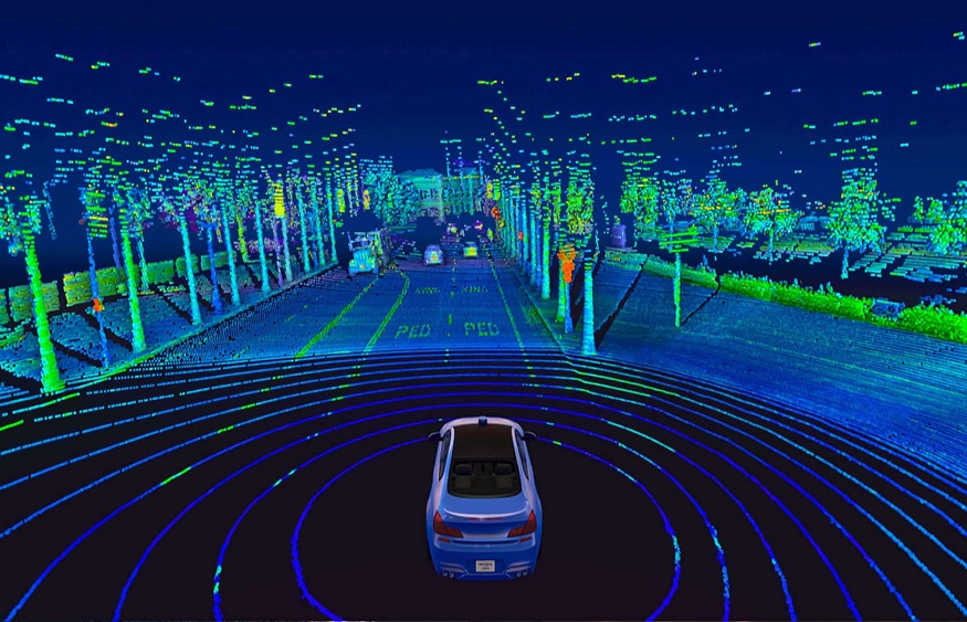
“LiDAR” is an acronym for “light detection and ranging.” In LiDAR, a transmitter emits laser light, which the scene’s objects reflect back to the device. The time of flight (TOF) is used to construct a distance map of the scene’s objects when the system receiver picks up the reflected light.
How does LiDAR work?
All LiDAR systems detect distance by accurately measuring the pulse that bounces back from a target after a precise, high-powered laser is fired at it, whether it is mounted to a plane, attached to a drone, or held in the palm of your hand.
Actually, LiDAR systems use light to calculate distance, whereas radar and sonar do it by using radio or sound waves. LiDAR payloads can determine the precise 3D coordinates of every place from which signals return, or bounce back, by taking into account the direction the light was emitted, the location of the LiDAR scanner, and the distance between two sites.
Advantages of LiDAR technology
1. Increased Accuracy
The LiDAR laser’s substantially greater precision is its first salient benefit. The system, for instance, can detect objects with diameters of 5 to 15 cm in the vertical and 30 to 50 cm in the horizontal. LiDAR will soon be employed for forest structural modeling and surveys thanks to its higher precision.
Additionally, the numerous outputs of Lidar enable the computation of intermediate levels in addition to surface and ground levels.
2. Little Dependence on Humans
LiDAR laser requires less human involvement than photogrammetry, GPS, or land surveying because most processes are automated. That is, it just needs small personnel and can even run alone.
This will eventually enable its deployment in locations like the North Pole or the South Pole, where humans cannot reside permanently owing to harsh weather conditions. The LiDAR laser can function effectively even with only a little human assistance.
3. Limited Weather Independence
LiDAR technology offers accurate 3D mapping even in bad weather or illumination conditions. This technology can be used with other local technologies to build an elaborate mapping system capable of accurate analysis.
It gives accurate information about moving objects like cars in bad weather or illumination circumstances and exact information about static objects. This is particularly noteworthy in the context of driverless vehicles.
4. Effective method
Another significant benefit of LiDAR technology is that it doesn’t rely much on a person’s presence or continual engagement with them. This indicates that because of its automated system, it can operate flawlessly independently in the majority of applications. People’s duties will also be more accurate, enabling successful development towards the overall project and saving time and money.
5. Aerial density variation at higher altitudes
LiDAR technology can pierce the ground, as we are already aware. With a high category density, this provides more in-depth information on an object or surface being investigated. It is highly helpful in applications where accurate data with a higher surface density are desired.
6. Low Cost
LiDAR is substantially less expensive than previous land surveying and mapping methods due to the speed and broad area that can be scanned along with the very accurate results. It is a cost-effective method for creating intricate topographical surveys.
7. May incorporate other technology
LiDAR data collection typically results in a difficult or time-consuming analysis and interpretation procedure, but it is compatible with other technologies. It would allow for the most sophisticated data analysis to be done effectively.
LiDAR technology applications
Now that we know what LiDAR is and how it operates, we can examine the numerous sectors now using LiDAR sensor technology.
1. Agriculture
A farm can use LiDAR technology to keep track of everything. LiDAR and agriculture are perfect for detecting crop-yielding regions, measuring flood flows to help locate levees, or tracking a roving herd of cattle. Even individual insects on a farm can be found using specific LiDAR setups.
2. Atmosphere
LiDAR scanners, particularly those that work from the air, have a variety of advantages and applications when it comes to matters of the atmosphere.Cloud profiling, pollution modeling, meteorology, and aid in determining the density and dispersion of different gases and molecules are a few of these.
3. Inspection
Inspection and maintenance can benefit immensely from the ability of drones or unmanned aerial vehicles with LiDAR payloads to visit regions that are either hazardous or impossible for human employees to access.Equipment utilizing a LiDAR scanner can significantly save the time and expense of a human survey or inspection, be it for monitoring the quantity of vegetation growing along a power line or completing early inspections of construction sites.
4. Accident scenes
Whether it’s a crash on a cold country road or a late at night interstate pileup LiDAR systems can gather a wealth of visual information in a single pass before the medics even show up, allowing emergency personnel to concentrate on saving lives right away rather than analyzing the scene. LiDAR technology can also be utilized in court as an objective, data-driven record that aids in determining the cause or effects of an accident. This includes maps, models, and other data. Such models might also be useful for sanitation teams and wreckers who are cleaning up after an accident.